

Tour du Semnoz - Cycling rout
Itinéraire

 Departure/Arrival
 Point of interest
Car Park: Préfecture


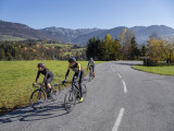
This moderately difficult climb begins with a shaded woodland ascent to reach the Col de Leschaux (897m), followed by a descent into the Vallée du Chéran, before finishing along the western side of the Semnoz.
A medium-difficulty route, it begins with a shady forest climb to the Col de Leschaux (897 m), followed by a plunge down to the Chéran valley. The route ends on the western flank of the Semnoz.
Points of interest
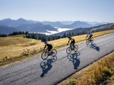
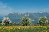
This is a great tour that allows you to take a look at the picturesque landscapes and sites in the heart of the Parc des Bauges. Discover the Diable and Abîme bridges, the Prérouge cave and the Chéran gorges.
Cycling tip
For the panoramic option, calculate the time to climb to the Col de Leschaux before the warm season.
Direction of travel: clockwise
Landmarks and connections: Sévrier (turn off with the Circuit de Leschaux n°8); Col de Leschaux; Gruffy (turn off with the Circuit de l'Albanais n°11 and Annecy-Aix les Bains n°51).
Description:
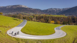
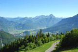
Apart from the road that runs along the Vallée du Chéran, (the only way out of the mountains), Coeur des Bauges is defended on all sides by high ridges, of which Leschaux is the lowest. 12km long with 480m of elevation change (with an average incline of 4%) and an even profile, it is the most popular route for cycling in the Haute Savoie and is perfect for beginners. To reach the foot of the mountain (RD912), leave the Voie Verte at the Port de Sévrier and follow the departmental road n°1508 for 1.5km towards Annecy, which you will reach after making a delicate left turn. Once you cross the ridge and reach the Vallée du Chéran (RD911), look out for a right turn onto the Route d'Allèves, which will take you to Annecy. But beforehand, we recommend that you make the 2km round trip to see the impressive Abîme bridge, it's worth it!
Points of interest
This is a great tour that allows you to take a look at the picturesque landscapes and sites in the heart of the Parc des Bauges. Discover the Diable and Abîme bridges, the Prérouge cave and the Chéran gorges.
Cycling tip
For the panoramic option, calculate the time to climb to the Col de Leschaux before the warm season.
Direction of travel: clockwise
Landmarks and connections: Sévrier (turn off with the Circuit de Leschaux n°8); Col de Leschaux; Gruffy (turn off with the Circuit de l'Albanais n°11 and Annecy-Aix les Bains n°51).
Description:
Apart from the road that runs along the Vallée du Chéran, (the only way out of the mountains), Coeur des Bauges is defended on all sides by high ridges, of which Leschaux is the lowest. 12km long with 480m of elevation change (with an average incline of 4%) and an even profile, it is the most popular route for cycling in the Haute Savoie and is perfect for beginners. To reach the foot of the mountain (RD912), leave the Voie Verte at the Port de Sévrier and follow the departmental road n°1508 for 1.5km towards Annecy, which you will reach after making a delicate left turn. Once you cross the ridge and reach the Vallée du Chéran (RD911), look out for a right turn onto the Route d'Allèves, which will take you to Annecy. But beforehand, we recommend that you make the 2km round trip to see the impressive Abîme bridge, it's worth it!
From 15/04 to 31/10.
Navigable during periods of no snow cover, subject to weather conditions.
Check beforehand with the Tourist Office for up-to-date information on access conditions.
Navigable during periods of no snow cover, subject to weather conditions.
Check beforehand with the Tourist Office for up-to-date information on access conditions.
General
- Route :
- Type of itinerary BOUCLE
- Distance (in km) 52
- Daily duration (in min) 210
- Maximum altitude (in m) 897
- Height difference (in m) 680
- Positive elevation gain (in m) 680
- Negative elevation gain (m) 680
- Levels of sporting experience :
- Level red – hard
Contact
Tour du Semnoz - Cycling rout
74000
Annecy
Phone : +33 4 50 45 00 33