

Pointe de la Galoppaz from Lindar
Itinéraire

 Departure/Arrival
 Point of interest
Circuit n° 1


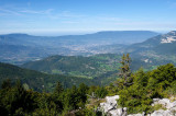
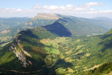
This itinerary is a great way for families to discover a beautiful summit in the southern part of the Massif des Bauges. The Pointe de la Galoppaz rises skywards from the valley, but is easy to reach. At the summit, picnic in front of a 360° panorama!
D/ Parking du Rond-Point du Lindar.
1/ Follow the path down to the stream, then up the other side, crossing the forest track to reach the Col de la Buffaz.
2/ At the pass, turn left onto the path that climbs again.
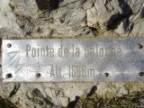
3/ Cross an enclosure and continue up to the summit at 1681 m. (about 45 minutes from the pass).
4/ Take the same route back.
------------------------------------------------------------------------------------------------------------
This route takes you through mountain pastures. Herds may be present. Remember to close the gates behind you to prevent the animals escaping.
If you have a dog, keep it on a lead to avoid frightening the herd.
1/ Follow the path down to the stream, then up the other side, crossing the forest track to reach the Col de la Buffaz.
2/ At the pass, turn left onto the path that climbs again.
3/ Cross an enclosure and continue up to the summit at 1681 m. (about 45 minutes from the pass).
4/ Take the same route back.
------------------------------------------------------------------------------------------------------------
This route takes you through mountain pastures. Herds may be present. Remember to close the gates behind you to prevent the animals escaping.
If you have a dog, keep it on a lead to avoid frightening the herd.
From 01/05 to 31/10.
Subject to favorable snow and weather conditions.
Subject to favorable snow and weather conditions.
General
- Equipements et services :
- Animaux acceptés
- Route :
- Type of itinerary Aller / Retour
- Marked route
- Distance (in km) 6.8
- Daily duration (in min) 240
- Maximum altitude (in m) 1681
- Height difference (in m) 520
- Positive elevation gain (in m) 520
- Negative elevation gain (m) 520
- Levels of sporting experience :
- Level bue - easy
Contact
Pointe de la Galoppaz from Lindar
Rond-point du Lindar
73340
Aillon-le-Jeune
Phone : +33 4 79 54 63 65