

La Pointe de Chaurionde
Itinéraire

 Departure/Arrival
 Point of interest
Circuit n° 1


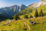
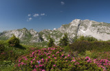
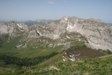
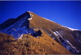
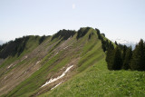
One of the highest summits in the heart of the Wildlife and Hunting National Reserve. This hike is suited to moderate hikers and includes steep passages. The wildlife (mouflons, chamois and marmots) are ever present.
From the car park go up towards the chalets d'Orgeval via a steep forest path, then a lane in the alpine pastures. Continue towards the Orgeval Pass (Col d'Orgeval), then take to the right the trail that goes up to the summit. Be careful, the last passage is steep on a grassy crest before the summit (avoid during rain and if you afraid of heights). Go back down the same way or via the ridge that leads to the Drison Pass (Col du Drison) to the east, then take the trail which crosses a steep slope to go as far as the pass and the chalets du Haut Four. Continue through the forest towards the car park.
From 05/01 to 10/31 : open daily.
General
- Route :
- Type of itinerary BOUCLE
- Marked route
- Distance (in km) 14.8
- Daily duration (in min) 390
- Maximum altitude (in m) 2173
- Height difference (in m) 1180
- Positive elevation gain (in m) 1180
- Negative elevation gain (m) 1180
- Levels of sporting experience :
- Level red – hard
Download
Contact
La Pointe de Chaurionde
Parking du Nant Fourchu
73630
École
Phone : +33 4 79 54 84 28