

Cycling up Mont-Revard from Aix-les-Bains


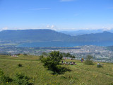
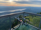
Departing from Aix les Bains, this climb takes you to the summit of Mont Revard, where you can enjoy a 360° view of the lake and Mont Blanc.
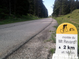
Although the summit altitude is moderate at 1538 m, it's a long climb that awaits you, with almost 1300 m of D+ to be climbed over the 22 kilometers. The slope is steady, however, and much of it is done in the shade of the forest.
Once you've reached the summit, you can either return down the Chambérien side of the mountain, or continue on into the Bauges.
This ascent totals 886 points on a squared grading scale.
Once you've reached the summit, you can either return down the Chambérien side of the mountain, or continue on into the Bauges.
This ascent totals 886 points on a squared grading scale.
All year round.
General
- Route :
- Type of itinerary Aller / Itinerance
- Marked route
- Distance (in km) 22.2
- Daily duration (in min) 120
- Maximum altitude (in m) 1530
- Height difference (in m) 1296
- Positive elevation gain (in m) 1296
- Negative elevation gain (m) 0
Equipment & Services
- Route :
- Type of itinerary Aller / Itinerance
- Marked route
- Distance (in km) 22.2
- Daily duration (in min) 120
- Maximum altitude (in m) 1530
- Height difference (in m) 1296
- Positive elevation gain (in m) 1296
- Negative elevation gain (m) 0
Download

Directions to :
Avenue Charles de Gaulle
73100
Aix-les-Bains
GPS coordinates
Latitude : 45.688187
Longitude : 5.909743
Contact
Cycling up Mont-Revard from Aix-les-Bains
Avenue Charles de Gaulle
73100
Aix-les-Bains
Phone : +33 4 79 88 68 00