

16 - Colombier d'Aillon Circuit


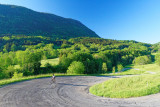

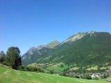
The climb to the Col des Prés is strenuous, but your efforts are rewarded with a magnificent descent into the heart of the Geoparc des Bauges. Exit via the Col du Frêne, with views over Mont Blanc. Can be started from Chambéry.
From 01/01 to 31/12.
Check beforehand with the Tourist Office for up-to-date information on weather conditions.
Subject to favorable weather.
Check beforehand with the Tourist Office for up-to-date information on weather conditions.
Subject to favorable weather.
General
- Route :
- Type of itinerary BOUCLE
- Marked route
- Distance (in km) 80
- Daily duration (in min) 330
- Maximum altitude (in m) 1150
- Height difference (in m) 1350
- Positive elevation gain (in m) 1350
- Negative elevation gain (m) 1350
Equipment & Services
- Route :
- Type of itinerary BOUCLE
- Marked route
- Distance (in km) 80
- Daily duration (in min) 330
- Maximum altitude (in m) 1150
- Height difference (in m) 1350
- Positive elevation gain (in m) 1350
- Negative elevation gain (m) 1350
Download

Directions to :
Buisson Rond
73000
Chambéry
GPS coordinates
Latitude : 45.565115
Longitude : 5.936213