
Snowshoe hikes : The Margériaz ridges
Itinéraire

 Departure/Arrival
 Point of interest


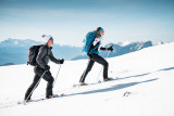
A very nice trek on the Massif du Margériaz. Mont Blanc is at your fingertips! The main peaks of the Bauges mountains are revealed before you, as well as the Belledonne range, not to mention the Chartreuse and Vanoise mountains.
The route is very pleasant, especially after a snowfall. There is no particular difficulty, as this is an introductory trail. The start follows the dog sled track. We therefore recommend that you hike on the side of the track. Dogs (even on a lead) are not allowed.
The slightly steeper sections are in the forest and only a few metres long. However, beware of the tannes (chasms) that you may find along the way. Take care in foggy weather, as orientation above the forest is trickier.
From the Place à Baban car park, head for the Tannes et Glacières summer footpath. Take the first path up into the forest, which indicates the caving hike* (*activity possible in winter with a guide). The route winds through the trees. There are red and purple markings. The route is very easy and varied: gentle climbs, slight descents, crossings, and as you go along you gain height. The route approaches the Alpage ski lift. Gradually, the trees become sparser and you leave the forest to discover the ski slopes on your right.
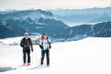
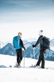
Continue up towards the cross at the Bergerie (high-altitude restaurant). Above this, the snowshoe trail runs alongside the Tasson trail (Savoyard for "badger"), past the Alpage ski lift and then the Bergerie ski lift, before leading to the ridge. Continue along the edge of the track above the rocky bars beyond the arrival station of the chairlift. There are several viewpoints from which you can admire the surrounding panorama.
After reaching the 1784m mark (IGN map), it takes around 15 minutes to reach the highest point: Mont Margériaz at 1845m. Descend a few metres and follow the panoramic footpath. The summit, marked by an IGN marker, is located above the Golet ski lift. Return by the same route or by chairlift (free, last descent at 4.30pm).
The slightly steeper sections are in the forest and only a few metres long. However, beware of the tannes (chasms) that you may find along the way. Take care in foggy weather, as orientation above the forest is trickier.
From the Place à Baban car park, head for the Tannes et Glacières summer footpath. Take the first path up into the forest, which indicates the caving hike* (*activity possible in winter with a guide). The route winds through the trees. There are red and purple markings. The route is very easy and varied: gentle climbs, slight descents, crossings, and as you go along you gain height. The route approaches the Alpage ski lift. Gradually, the trees become sparser and you leave the forest to discover the ski slopes on your right.
Continue up towards the cross at the Bergerie (high-altitude restaurant). Above this, the snowshoe trail runs alongside the Tasson trail (Savoyard for "badger"), past the Alpage ski lift and then the Bergerie ski lift, before leading to the ridge. Continue along the edge of the track above the rocky bars beyond the arrival station of the chairlift. There are several viewpoints from which you can admire the surrounding panorama.
After reaching the 1784m mark (IGN map), it takes around 15 minutes to reach the highest point: Mont Margériaz at 1845m. Descend a few metres and follow the panoramic footpath. The summit, marked by an IGN marker, is located above the Golet ski lift. Return by the same route or by chairlift (free, last descent at 4.30pm).
From 15/12 to 01/04 daily.
You assume full responsibility for your snowshoeing.
Subject to snow conditions.
You assume full responsibility for your snowshoeing.
Subject to snow conditions.
General
- Route :
- Type of itinerary Aller / Retour
- Marked route
- Distance (in km) 8
- Daily duration (in min) 210
- Height difference (in m) 480
- Positive elevation gain (in m) 480
- Negative elevation gain (m) 480
- Levels of sporting experience :
- Level bue - easy
Download