

Traversée du Semnoz - Cycling route


This itinerary takes you up the northern side of the Semnoz and down the Col de Leschaux, for a challenging crossing of this peak with its breathtaking panoramas.
The Semnoz, the "mountain of the people of Annecy", hosted a Tour de France finish at the summit!
Points of interest
For once, this sporting loop provides an opportunity to finish the ascent at a summit rather than a pass, and what a summit it is! Discover the Col de Leschaux on the way down.
Cycling advice
Be in good shape for the direct ascent via Quintal, with sections at 10.5 and 11.5%.
Direction: counter-clockwise.
Landmarks and connections: Col de Leschaux (junction with Circuit de Leschaux no. 8); Sévrier (return on the voie verte).
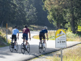
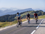
Description: The figures speak for themselves: over 17 km at an average gradient of almost 7%, with several kilometers above 9%. Don't set off without some training on lesser passes. On a positive note, you'll have the coolness to yourself, as the climb is north-facing and takes place entirely in forest.
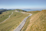
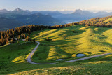
The climb starts in town, at the hospital roundabout. At the top of avenue du Trésum, take boulevard de la Corniche, then follow départementale 41 without interruption. After the fifth kilometer, you'll have 3 km of flat land to breathe in. After that, the effort is continuous. In addition to its athletic cycling profile, the Semnoz has another merit: its exceptional panoramic views. It's a high (1,699 m), isolated peak, standing watch on the edge of the northern Alps: from a circular vantage point you can see the peaks of the Valais, the Mont-Blanc massif, the Aravis, the Beaufortain, the Vanoise, the Bauges and the Chartreuse, among others!The descent is a two-stage affair: first, there are magnificent switchbacks to the Col de Leschaux, then a winding, gently sloping road to Sévrier, where you join the voie verte after 1.5 km, on the right-hand side of the departmental road.
Points of interest
For once, this sporting loop provides an opportunity to finish the ascent at a summit rather than a pass, and what a summit it is! Discover the Col de Leschaux on the way down.
Cycling advice
Be in good shape for the direct ascent via Quintal, with sections at 10.5 and 11.5%.
Direction: counter-clockwise.
Landmarks and connections: Col de Leschaux (junction with Circuit de Leschaux no. 8); Sévrier (return on the voie verte).
Description: The figures speak for themselves: over 17 km at an average gradient of almost 7%, with several kilometers above 9%. Don't set off without some training on lesser passes. On a positive note, you'll have the coolness to yourself, as the climb is north-facing and takes place entirely in forest.
The climb starts in town, at the hospital roundabout. At the top of avenue du Trésum, take boulevard de la Corniche, then follow départementale 41 without interruption. After the fifth kilometer, you'll have 3 km of flat land to breathe in. After that, the effort is continuous. In addition to its athletic cycling profile, the Semnoz has another merit: its exceptional panoramic views. It's a high (1,699 m), isolated peak, standing watch on the edge of the northern Alps: from a circular vantage point you can see the peaks of the Valais, the Mont-Blanc massif, the Aravis, the Beaufortain, the Vanoise, the Bauges and the Chartreuse, among others!The descent is a two-stage affair: first, there are magnificent switchbacks to the Col de Leschaux, then a winding, gently sloping road to Sévrier, where you join the voie verte after 1.5 km, on the right-hand side of the departmental road.
From 15/04 to 31/10.
General
- Route :
- Type of itinerary BOUCLE
- Distance (in km) 51
- Daily duration (in min) 165
- Maximum altitude (in m) 1655
- Height difference (in m) 1250
- Positive elevation gain (in m) 1250
- Negative elevation gain (m) 1250
Equipment & Services
- Route :
- Type of itinerary BOUCLE
- Distance (in km) 51
- Daily duration (in min) 165
- Maximum altitude (in m) 1655
- Height difference (in m) 1250
- Positive elevation gain (in m) 1250
- Negative elevation gain (m) 1250

Directions to :
Parking de la Préfecture
74000
Annecy
GPS coordinates
Latitude : 45.90178
Longitude : 6.130279
Car Park: Préfecture
Contact
Traversée du Semnoz - Cycling route
Parking de la Préfecture
74000
Annecy
Phone : +33 4 50 45 00 33